
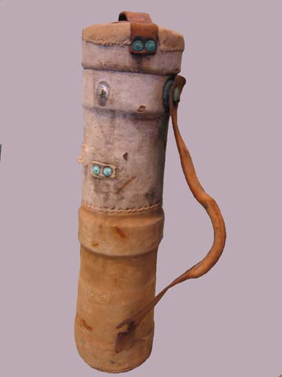
Case, Chart
Garden of the Gulf Museum
Tous droits réservés.
| Nom de l'objet : | Case, Chart |
| Type de l'objet : | Case, Chart |
| Catégorie de l'objet : | Distribution & Transportation Artifact |
| Sous-catégorie de l'objet : | Water Transportation - Accessory |
| Discipline : | Material culture |
| Matériaux : | brass wood canvas leather |
| Numéro d'accession : | GG.01.1.1 |
| Fabricant : | unknown |
| Culture : | Canadian |
| Date de début de production : | 1930, c |
| Date de fin de production : | 1960, c |
| Description : | Cylindrical case for carrying sea charts. The case is wrapped in layers of canvas to provide water proofing. Leather straps are attached to the case with brass buttons. The top of the case is removable. |
| Commentaires : | This chart case belonged to Charles Collier, originally from Newfoundland and Labrador and later of Machon's Point, Murray Harbour, eastern Prince Edward Island. Charles Collier spent much of his life at sea. Sea charts have been an invaluable asset to mariners since the Middle Ages, and are still used today - albeit in electronic form - to assist mariners in navigating the open seas. The first known sea charts, called portolans, date to the 13th century and were typically drawn on parchment or vellum, which was more water-resistant and certainly more common than paper. The Dutch dominated the sea chart industry into the late Middle Ages and early Renaissance. The first known atlas of sea charts was Lucas Waghenaer's Spieghel der Zeevaerdt, published in 1584. The English translation of Waghenaer's work, The Mariner's Mirror, was published in 1588 and became so popular that any volume of sea charts soon became known as a "waggoner". By the late 17th century, the French had come to dominate the market, and by 1720 they had devoted an official government agency, the Depot des cartes et plans de la Marine, to mapping and charting. Official charts published by the Depot des cartes et plans de la Marine and later the British Hydrographic Office of the Admiralty and American U.S. Coastal Survey were distinguishable from privately published charts by the quality of the paper and lack of blue manila backing. Private charts were typically printed on lesser-quality paper, so a blue manila backing was added to improve the chart's lifespan. Separately issued sea charts are highly sought after. The combination of an adverse environment and the practice of destroying out-of-date sea charts to ensure that they would not be used inadvertently makes them quite rare and valuable. |
| Fonctions : | Used to store sea charts and keep them dry. |
| Hauteur : | 64 |
| Diamètre extérieur : | 16 |
| Établissement : |
Garden of the Gulf Museum
|
| Ville de l'établissement : | Montague |
| Province de l'établissement : | Prince Edward Island |
Coordonnées de cette page web
-
Pour proposer des corrections ou des mises à jour sur cette page, veuillez contacter directement le Réseau canadien d’information sur le patrimoine (RCIP).