
Map


Kings County Museum of New Brunswick
Tous droits réservés.
| Nom de l'objet : | Map |
| Catégorie de l'objet : | Communication Artifacts |
| Sous-catégorie de l'objet : | Documentary Artifact |
| Matériaux : | Paper Cardboard |
| Numéro d'accession : | 1967.137.04 |
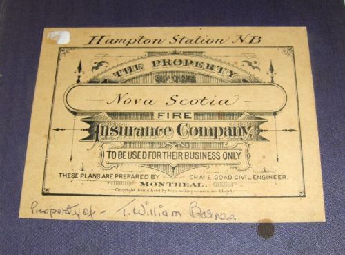
| Description : | Map of Hampton Station - 1888 - Revised - 1900, was done by the father of the donor, Mrs. George Booth [ nee Marjorie Peirs ] [ History Box - H - 118 ] |
| Commentaires : | This map of Hampton Station was prepared for the Nova Scotia Fire Insurance Comapny in 1888, then revised in 1900. The map provides a detailed view of the businesses and habitations of Hampton Station from the late 1800s. The original survey was completed by in 1888, with revisions to 1900 - one of the revisons was to the listed population; originally noted at 400 persons in 1888, the 1900 updated notes a population now of 500. The map key contains details on physical characteristics of each structure. Notations for the Ossekeag Stamping Co. even details the number of hands, the hours worked, and the number of watchmen. The map includes whether structures are of brick or wood, shingle type, roofline type, window placement, etc. The map states the town water source as the Kennebecasis River. |
| Hauteur : | 33 |
| Largeur : | 19 |
| Unité de mesure linéaire : | cm |
| Nombre d'objets : | 1 |
| Établissement : |
Kings County Museum of New Brunswick
|
| Ville de l'établissement : | Hampton |
| Province de l'établissement : | New Brunswick |
Coordonnées de cette page web
-
Pour proposer des corrections ou des mises à jour sur cette page, veuillez contacter directement le Réseau canadien d’information sur le patrimoine (RCIP).