
Blueprint
Museums of Mississauga
Tous droits réservés.
| Nom de l'objet : | Blueprint |
| Titre : | A.B. Harris Estate |
| Numéro d'accession : | BR2013.2.37 |
| Date de début de production : | 1900 |
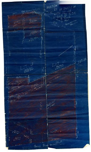
| Description : | Blueprint or mechanical drawing of the A.B Harris Estate. Consists of white printing on blue paper. Some sections of drawing are shaded in with red crayon. Title at top reads: "Sketch of parts of Lots 27 & 28 Con I S.B.S Tp. Toronto, Co. Peel". On the back in pencil, is "A.B Harris Estate". Drawing has been folded lengthwise once and then five times horizontally. Printing on document reads: "Lot 28 - 148.5 acres, Lot 27-136 acres". |
| Fonctions : | James Beveridge Harris purchased Benares house and the surrounding land in 1836 from Edgar Neaves; the property was a total of 284.50 acres and was located on Lots 27 and 28, Concession II, South of Dundas Street. The property went as far north as the QEW, as far south as railway tracks, east towards Lorne Park Road and west towards Clarkson Road. After Captain Harris passed away in 1884 ownership of house and property was given to his son Arthur Beveridge Harris. Arthur gave the southern 38 hectares of the arm to his daughter Annie in 1911 as a wedding present. He later sold 5.50 acres of land to the Hydro Electric Power Commission in Ontario back in 1913 for use of a power line. Parcels of Benares property have been sold in the later years and all that remains is 2.3 hectares or less than one percent of the original property. |
| Établissement : |
Museums of Mississauga
|
| Ville de l'établissement : | Mississauga |
| Province de l'établissement : | Ontario |
Coordonnées de cette page web
-
Pour proposer des corrections ou des mises à jour sur cette page, veuillez contacter directement le Réseau canadien d’information sur le patrimoine (RCIP).