
Map
MacBride Museum
Tous droits réservés.
| Nom de l'objet : | Map |
| Numéro d'accession : | 1977.63.1 |
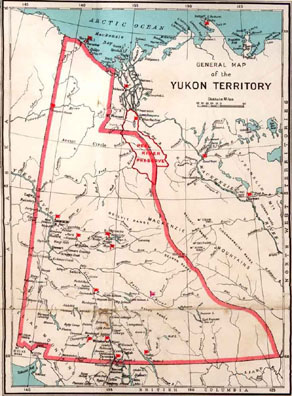
| Description : | A map of the Yukon Territory circa 1929. The legend, located at the bottom proper left reads, "Post Offices, RCMPolice Posts, Road Houses, Railways, Telegraph Lines, Roads, Trails, International Boundary, Provincial Boundary, Elevation of land above sea level, Elevation of water above sea level." In the center, at the bottom it reads, "Yukon Territory, 1929", with a scale below that denotes an inch equals a mile. On the bottom proper right it reads, "Wireless stations in the Yukon Territory are located at the following points: - Dawson, Mayo, Herschel and Aklavik". |
| Sujet ou image : | Mounties |
| Établissement : |
MacBride Museum
|
| Ville de l'établissement : | Whitehorse |
| Province de l'établissement : | Yukon Territory |
Coordonnées de cette page web
-
Pour proposer des corrections ou des mises à jour sur cette page, veuillez contacter directement le Réseau canadien d’information sur le patrimoine (RCIP).