
Map
Bideford Parsonage Museum
Tous droits réservés.
| Nom de l'objet : | Map |
| Artiste ou artisan : | H.W. Bayfield, H.J. Cundall |
| Type de l'objet : | Map |
| Catégorie de l'objet : | Communication Artifact |
| Sous-catégorie de l'objet : | Documentary Artifact |
| Discipline : | material culture |
| Matériaux : | Paper, wood |
| Numéro d'accession : | BPM.00.0079 |
| Fabricant : | G. Ballingall |
| Culture : | Canadian |
| Date de début de production : | 1903 |
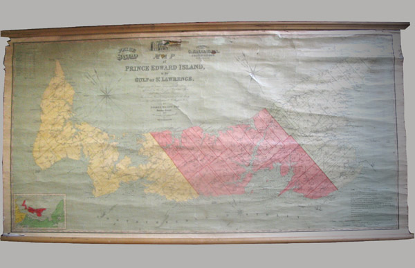
| Description : | Map; Paper, wood. Rectangular map depicting Prince Edward Island and surrounding waters. At each long side of map is attached a wooden pole, which makes for easy hanging and rolling up. Torn slightly, top left corner. Top centre: Image of a building. "Colonial Building, Charlottetown." Top Centre Left: "Price / $5.00" Top Centre Right: "Published / by / G. Ballingall / Charlottetown / P.E. Island" Centre, above map details: (smaller script) "Map / of / Prince Edward Island / in the / Gulf of St. Lawrence / Comprising the latest topographical information / afforded by the Surveyor General's office / and other authentic sources. / The Sea Coast Rivers, etc. being laid down from the Survey / reentry completed by Captain H. W. Bayfield R.N." / (Larger Print) "By / George Wright Esq. / Surveyor General / 1852 / With corrections and additions to 1903 / by / H.J. Cundall, L.S." Bottom Right Corner: "Reference / Prince Edward Island Railway and Branches shewing the situation / of stations and distances from Charlottetown. / 1, 2, 3, & No. OF Lot or Township. / The Soundings are in Fathoms reduced to Low Water Spring Tides. / Public Roads *lines indicating roads* / Churches E.C. Eng, Epis, Pres. Presbyterian, Wes. Westeyan Methodist, Bap. Baptist, B.C. Bible Christians, R.C. Roman Catholic, P.O. Post Offices / Water Mills G Grist Mills S Saw Mills C Carding Mills / The Population of each township according to the census of 1848 and 1855 and 1871 and 1901 / is expressed in the figures under the NO. of each thus Census of 1871, 1498 / Census of 1901, 1918 / 1178 Census of 1848 / 1285 Census of 1855 / Total Population of the Island in 1848 62,678, in 1855 71,496, 1861 81,000, 1871 94,021, 1901 103,259 / Each Township contains about 20,000 Acres Total Acres 1,365,400 / Boundaries of Townships *line indicating boundary* / Boundary of Parishes and Townships *line indicating boundary* / Boundaries of Counties, Parishes, and Townships *line indicating boundary* / X.XL to denote the distances from Charlotte Town" |
| Commentaires : | The map was bought for $20.00 CD at an estate sale in Souris, PEI. It would have once been used in one of the Island's one room school houses. The surveyor, Captain Bayfield, spent most of his career surveying the Great Lakes and other water areas around Quebec and Ontario, but in 1941 he moved his headquarters to Charlottetown, PEI. After this move he concentrated his efforts on PEI and Nova Scotia for the next 15 years. He retired from surveying in 1856, eventually became an Admiral in 1867, and continued to live in Charlottetown until his death in 1885. |
| Fonctions : | Map used in a schoolhouse for reference |
| Longueur : | 71 |
| Largeur : | 147 |
| Établissement : |
Bideford Parsonage Museum
|
| Ville de l'établissement : | Bideford |
| Province de l'établissement : | Prince Edward Island |
Coordonnées de cette page web
-
Pour proposer des corrections ou des mises à jour sur cette page, veuillez contacter directement le Réseau canadien d’information sur le patrimoine (RCIP).